11 Years Later: Life After Hurricane Sandy
In the unprecedented hurricane season of 2012, Hurricane Sandy hit the hardest.
The deadliest and most destructive storm of the year, Sandy raged throughout 24 states, killing 233 people and inflicting nearly $70 billion of damage in the US alone. The storm made official landfall 3 times: in Jamaica on October 24, in Cuba on October 25, and in New Jersey on October 29. Although it was not technically classified as a hurricane by the time it made landfall in the United States, Sandy’s sheer size and path, caused by a convergence of several different storms, played a role in the devastation it caused.
Perhaps because of this, it was unofficially dubbed Superstorm Sandy by the media and, in some cases, a Frankenstorm.
Even over a decade later, the communities hit by Sandy feel its impact.
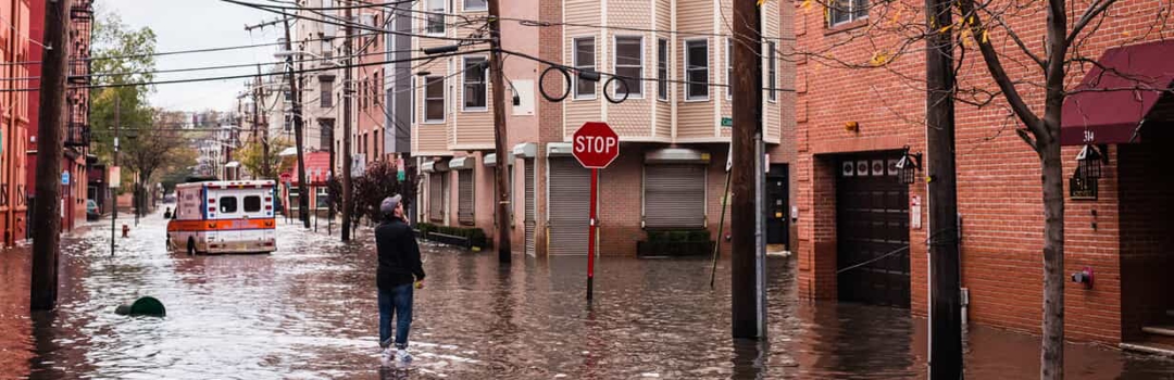
Hurricane Sandy’s Impact on New York City
Sandy hit New York City and Long Island between October 29-30, causing catastrophic damage the likes of which the city had never seen before. It was the storm’s terrible timing that heightened the devastation: it coincided perfectly with a spring tide and full moon—which brought about abnormally high tides—and its diameter stretched 1,000 miles from end to end, over three times the size of Katrina.
By diameter, it was the largest Atlantic hurricane ever recorded.
The previous record was set by Hurricane Donna in 1960 when a storm surge at the Battery reached 10 feet. Sandy generated a storm tide of over 14 feet in the same area. A total of 51 square miles of New York City flooded, impacting 443,000 residents and 88,700 buildings. The depth of the floodwaters was significant enough to flood the NYC subway system.
In the wake of the superstorm, the NYC Mayor’s Office of Housing Recovery Operations (HRO) launched the Build It Back program, which was meant to return families to their homes. The program underwent an overhaul in 2014 with an expectation set by Mayor Bill de Blasio that the work would be completed by the end of 2016. Finally, as of early 2021, nearly 99% of housing applicants had received their full benefits.
The U.S. Army Corps of Engineers was called in to help with the recovery, with immediate response covering the removal of debris and the securing of electrical generators to combat the widespread power outages. Ten years later, the response is nearly complete, despite expectations that long-term repairs might take decades, according to Joseph Forcina, chief of the Civil Works Integration Division of the U.S. Army Corps of Engineers, North Atlantic Division.
City planners investigated the ways that different areas of NYC were affected by the storm, learning how to better prevent future damage by creating strategic buffers. Meanwhile, homeowners and businesses were forced to rethink their lack of flood insurance or to fight the insurance companies to get the coverage that they were owed. In fact, more than 600,000 housing units were destroyed throughout New York and New Jersey, totaling about $19 billion in damages in New York City alone.
Hurricane Sandy’s Impact Beyond NYC
Although it made landfall in New Jersey, the effects of Hurricane Sandy were felt from Florida to Maine. Before it even reached the U.S., the storm hit Cuba, Haiti, the Bahamas, Puerto Rico, and the Dominican Republic.
As widespread as the damage was in terms of sheer square mileage, so too were the types of side effects that Hurricane Sandy imposed. It set low air pressure records in Atlantic City, Baltimore, Philadelphia, and Trenton; in Atlantic City, closest to landfall, the air pressure fell below the record set in 1932.
Why Air Pressure Records Should Concern Authorities
The implications of low air pressure are two-fold: one, low air pressure generally means lower temperatures. Consider how much colder it is at higher altitudes; the low-pressure effects of Hurricane Sandy meant its powerful winds and rainfall were colder than other hurricanes of comparable power.
The second implication of low air pressure is the production of stronger storms. Low air pressure means a fiercer and more rapid suction of air to rush into the area. This feeds storm systems, creating enormous clouds and thunderheads.
Storm Surges, Flooding, & Massive Snowfall Lead to Power Loss
The storm surge was also record-setting, overwhelming coastal New Jersey, New York City, Connecticut, and Rhode Island. Damaging high winds impacted communities as far as Michigan, forming whitecaps on Lake Michigan while the Atlantic Ocean sloshed inland on the Eastern Seaboard. A staggering 34 inches of snow fell in Gatlinburg, Tennessee, and heavy snow blanketed Maryland, Pennsylvania, Virginia, and West Virginia.
In the aftermath of the dangerous storm, other hazards came to light: as many as 8.5 million people across 21 states were left without power for weeks, and fire wreaked havoc in neighborhoods short-circuited by seawater. Thousands were evacuated from hospitals and left to fend for themselves without medication or care for weeks on end.
More than 20,000 households were still displaced a year after Sandy hit, with more than 1,000 New Jersey residents still unable to return home 5 years after the storm.
As of 2019, many cities on the East Coast still need more funding to build preventative barriers.
Recognition a Decade After Landfall
Starting in September 2022, as a recognition of the 10-year anniversary of the storm’s landfall, two Rutgers Cooperative Extension programs collaborated with the Earth Day, Every Day (E2D2) program and the Marine Extension Program Seminar Series (MEPSS) to put on a webinar series investigating the ongoing effects and recovery that New Jersey continues to weather.
The program includes sessions such as:
- “From One Extreme To Another: Climate Change Driven Storm Events And What To Do About Them”
- “Beyond Recovery From Sandy: Setting The Stage For Future Community Resilience”
- “Adapting To Climate Change In Your Community”
- “Living Shorelines In The Decade Since Sandy: Lessons Learned And Implications For Future Design”
- “Strategies To Minimize The Impacts Of Coastal Flooding And Salt Water On Agricultural Lands”
- “Planning For The Unplanned: Preparing For Marine Debris Response In New Jersey”
Preparing for Future Hurricanes
The MTA in New York City is preparing for the next climate disaster. From building a 14-foot perimeter wall stretching 12,000 feet around Coney Island Yard to elevating power cables to save them from storm surges, the MTA is taking storm mitigation seriously.
The National Oceanographic and Atmospheric Administration (NOAA) predicts that the sea level along the East Coast of the United States will rise between 10-12 inches by 2050. Oceanfront communities in New Jersey are combatting this by distributing sand amongst themselves; for example, North Wildwood, which is losing sand at an alarming rate, trucks it in every spring from Wildwood City, which has too much sand. This was expected to change in 2023, when the Army Corps of Engineers was supposed to take over the care of North Wildwood’s beaches to protect them—and others like them—from sea-level rise and future storms.
Legal Obstacles to Protecting New Jersey Beachfront Communities
However, 2023 may see no protections for one of New Jersey’s most economically and ecologically important beaches. The city of North Wildwood has sued New Jersey State for $21 million, which is how much they’ve apparently spent on battling erosion. New Jersey has countersued for $12 million, claiming that North Wildwood made beach restoration projects without proper approval. The litigation has halted any ongoing restoration efforts the Army Corps of Engineers might have conducted.
What Are the Odds Another Hurricane Sandy Occurs This Decade?
Hurricane formation comes from a simple process: as moist air sitting above the ocean heats, it rises, creating a vacuum underneath that is rapidly filled by more air. The rising warm air rapidly cools and condenses, forming clouds. As more warm air rises, the density of these clouds grows, eventually creating a storm system. Not all of these hurricanes are dangerous or even reach landfall.
However, scientists have noticed that there are more powerful hurricanes hitting our shores than in previous decades. While physics sets a hard limit on the strength and power of a hurricane (hence why we don’t see “Category 6” storms), the frequency of Category 3 and 4 storm systems has grown over the last few decades. While only four Category 5 hurricanes have ever made landfall in the US in the last century, two of them occurred in the last 30 years. Shortly after Katrina, the National Science Foundation reported that the total number of Category 4s and 5s doubled.
Technically, Hurricane Sandy wasn’t even a Category 5, but it still devastated countless lives. So is it possible we’ll see another storm on the scale of Hurricane Sandy this decade? Scientists believe it’s likely.
Over a decade after Superstorm Sandy, New York, New Jersey, and several other affected communities are still recovering. At the same time, they are also preparing—in a period of watchful wait, as described by Malcolm J. Bowman, professor of oceanography at the School of Marine and Atmospheric Sciences—to ensure that the infrastructure is in place to weather the next big storm.